

I just wanted to publish a quick post highlighting a big update to the Maps section of BoothieBarn. First, I have added about 30 more sites to the D.C., Maryland, and Northern Virginia map, bringing the total up to over 120 sites on this map alone. Maps for other regions of the U.S. are planned, but, since most of the action occurred in the Maryland area, I have been focusing on adding to and improving that map first. To that end, I have gone through and added a new aspect to the map which should make it even easier to locate and visit these sites, especially “on the go”.
We know, from studying an event that occurred 150 years ago, that landscapes have changed. In many instances, places that were once isolated farms and open land are now housing developments or busy highways. Old roads are lost to new roads and bypasses. Due to this, it is important to mark historic sites with something more long term than a street address, which could change (or disappear) in a few short years. Recording latitude and longitude coordinates based on the Global Positioning System (GPS) is, therefore, the best way to mark sites on an ever changing landscape. Regardless of what transformation occurs on the site itself, the GPS coordinates will always mark what was once there.
With this in mind, I have gone through and added the GPS coordinates for every site marked on my map. This is not only for posterity’s sake, but also serves to improve the functionality of the map itself. Practically every “smart” cell phone built today has the capability of providing driving directions. Now, with the GPS coordinates included in the description for every Lincoln assassination site, all you have to do is click the place you want to visit on my map, copy the GPS coordinates, and direct your phone or GPS device to give you directions there.
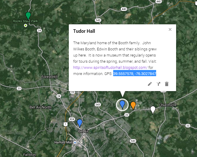
For places like cemeteries, the GPS coordinates are even more helpful, as they direct you almost exactly to the grave you are looking for. No more wandering around a huge cemetery hopelessly looking for that one grave. My coordinates will put you right at it. As I visit more graves in more cemeteries (using a wonderful book by Jim Garrett and Rich Smyth as my guide), I’ll be updating the map with even more grave GPSes.


So, if you’re planning a trip to the area or, better yet, planning to drive John Wilkes Booth’s escape route on your own, be sure to check out my D.C., Maryland, and Northern Virginia Lincoln assassination map for all the GPS coordinates you’ll need.


This is a great resource, Dave
Thank you, Kathy. Trust me, this is as much for me and my forgetful memory as it is for everyone else. Looking forward to seeing you at the conference.
Dave, this map section is really well done. Great job.
Thank you, Heath. By the way, I’d love to see some more tweets from you, especially as the 150th gets closer. I miss getting tweets from @ALassassination.
You are the best. Pretty sure I’m in love with you because of this